Creating a Ground Scale Coordinate File in STAR*NET
Customer Interview

Tim McCall
Managing director of McCall Consulting
In today’s video, we sit down for a STAR*NET chat with Tim McCall, managing director of McCall Consulting. Mr. McCall has a Bachelor’s in Surveying from Queensland University and has worked in Construction, Mining, Hydro, GIS, and Legal surveying over a 40-year career. Tim is a certified MicroSurvey STAR*NET trainer and provides customized training to clients.
STAR*NET: Ground Point file output
In STAR*NET, it is easy to create a “ground points” file of transformed adjustment results. STAR*NET allows you to set rotations, translations, and transformations to create a secondary set of adjusted coordinates, which may include ground coordinates, localized site-specific coordinates, or coordinates in an adjacent zone to your current coordinate system. Where other adjustment programs typically force you to create coordinates in one coordinate system and manually compute localizations by some other method, STAR*NET allows you to create both simultaneously.
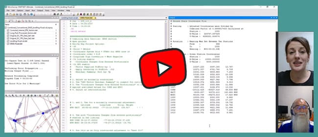
“STAR*NET is a really great feature for localized things and it’s one of the easiest packages to create a ground scale coordinate file”
– Tim McCall
Have a look at our interview with Tim and head over to microsurvey.com to download a trial version and check out the latest news on STAR*NET.
Thank you for your continued support and trust in our products. We look forward to hearing your feedback and are here to assist you with any questions you may have.